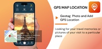
Capture and share your special moments with precise geographical details using GPS Photo Location on Map. This Android app allows you to take photos with embedded location, weather, date, and time information directly in the image. Whether you are traveling or exploring nearby places, the app records your real-time GPS coordinates and integrates them into your photos, creating a seamless way to document your journeys or activities.
Enhance Photos with Location and Weather Details
GPS Photo Location on Map lets you add essential location elements such as maps, latitude, longitude, altitude, weather conditions, and timestamps to your photos. These details can be inserted while taking pictures or applied later to images from your gallery, making it an ideal tool for travelers, event documenters, or users who need location-stamped visuals for professional or personal use.
Customizable Tools for Unique Photo Outputs
The app features advanced personalization options, allowing you to adjust the placement, color, and style of timestamps on your images. It supports the addition of custom text, offering the flexibility to include annotations or important notes. The live preview function ensures that all adjustments are accurate before capturing the image, ensuring tailored results to suit your needs.
Seamless Camera Functions and Advanced Features
With practical tools like autofocus, zoom, a remote timer, and multiple aspect ratios, GPS Photo Location on Map achieves professional-grade functionality for every user. The app also includes assistive grids, auto-rotate modes, and shooting-quality adjustments for enhancing the photography experience, catering to both casual and advanced users.
Requirements (Latest version)
- Android 6.0 or higher required


Comments
There are no opinions about GPS Photo Location on Map yet. Be the first! Comment